Propagation, Band Conditions and Solar Data
Disclaimer & Acknowledgments: This page is a non-commercial, educational resource created for the amateur radio community. The propagation charts, graphs, and images displayed here are aggregated from various external sources. All rights, trademarks, and copyrights remain with their respective owners. I do not claim ownership of these third-party materials. If you are the owner of any content shown here and wish for it to be removed or credited differently, please contact me and it will be addressed immediately.
Current Alert: Several global data feeds (KC2G/GIRO) are currently reporting stale data.
Current Conditions
Image & Data © Paul L Herrman, N0NBH.
Band Conditions MUF (3000km)
MUF is the highest frequency that is expected to bounce off of the ionosphere on a path 3000km long.

Map & Data © Andrew Rodland, KC2G. Contains data from Lowell GIRO Data Center.
Band Conditions Critical Frequency (foF2)
This map shows the highest frequency that you can use for NVIS.

Map & Data © Andrew Rodland, KC2G. Contains data from Lowell GIRO Data Center.
Solar X-Rays (NOAA)
Watch for spikes on the right side (Solar Flares).
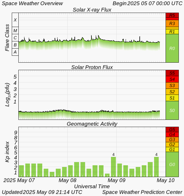
Image courtesy of the U.S. Dept. of Commerce, NOAA, Space Weather Prediction Center (Public Domain).
Day/Night Boundary (Greyline)
Best for low-band DX along the shadow line.
Sunlight Map © Paul L Herrman, N0NBH.
Additional Resources
- 📡 View Live SWS Global foF2 Map
- 📊 Click here for the Live DXPredictor MUF Interactive Map
- VOACAP Online HF Predictions – Maintained by Jari Perkiömäki, OH6BG.
- Proppy HF Propagation Prediction – ITURHFPROP-App based on ITU-R P.533-14 recommendations. Highly recommended if you intend to host the Proppy tool yourself for an independent, local setup.
- DR2W DX Propagation – Provided by the DR2W Contest Group.
- Space Weather Overview
- Current D-Layer Absorption